|

|
 GPS für Google Earth
-
Version
2.0
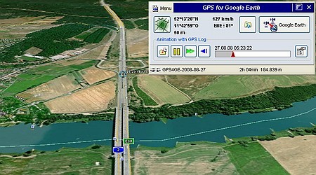
"GPS for Google Earth" converts the free Google-Earth-
Version into to a realtime GPS-navigation for laptop
and netbook. The own GPS-position it shown and
tracked in real time in "Google Earth". Also by
night, with fog or mist you'll see your current
movement like on a bright day on the screen.
Each tour is automatically recorded. One may play
animations of formerly recorded GPS logs.
Each one how owns a Laptop or Netbook has with "GPS
for Google Earth" a navigation tool for the road,
offroad, on the water or on the air.
In addition one needs only a little GPS receiver.
There's no need to bye a full navigational system. A
so called GPS mouse or a GPS USB dongle are available
in low cost level.
The connection may be established by cable, USB or
Bluetooth. The software itself is'nt restricted to a
special manufacturer.
The program works with each GPS Receiver that
provides NMEA. But this is the case for all
commercially available receivers.
The program is'nt retricted to only one country. The
GPS reception works all over the world and is
independent of the internet. Even in fare-away places
you'll find a way there and back.
Even without mobile internet one may use the system
out of the home. "Google Earth" remembers images and
maps once shown in the screen in its so called Cache
memory.
If you revise calmly at home all interesting areas
(you plan to visit on a tour) in "Google Earth" with
an active internet conmection, all this maps stay
available in "Google Earth" even after disconnecting
the internet. Now you may take the Latop into the car
or on the boat and will have all necessary maps "in
the bag".
|